Antonio Millo
[Παγκόσμιος χάρτης], Antonius Millo Cosmographus F 1582
Παγκόσμιος Χάρτης
1582, 0
Τεχνική: Χειρόγραφος
Κατηγορία: Ναυτικός Χάρτης
Διαστάσεις: 865 x 432 mm
Λονδίνο, British Museum, Add. 2740
London, British Museum, Add. 2740
British Museum, Catalogue of Additions (1861-1875).A. E. Nordenskiöld, Periplus: An Essay on the Early History of Charts and Sailing- Directions, Stockholm 1897, 67. F. W. Hasluck, Notes on manuscripts in the British Museum, relating to Levant geography and topography, The Annual of the British School at Athens 12(1905-6), 199.
George Tolias, The Greek Portolan Charts 16th -17th century, Athens, Olkos for the NHRF, 1999, AM.3.
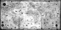
Ο χάρτης τιτλοφορείται ως ακολούθως: Tuto el disco perto in carta marina in piano. Πρόκειται για γεωγραφικό κυρίως χάρτη, ο οποίος διατηρεί στοιχεία από την παράδοση των ναυτικών χαρτών, όπως τον τρόπο αναγραφής των παρακτίων θέσεων, τις πυξίδες και τα ανεμολόγια. Δεν περιλαμβάνει μαρτελόγιο, αλλά κάναβο παραλλήλων και μεσημβρινών καθώς και κλίμακα γεωγραφικού πλάτους, στα δυτικά της Αφρικής. Σημειώνονται οι κύριες κλιματικές ζώνες (Circolo Artico, Tropico de Cancro, Equinociale, Tropico de Capricorno). Ο χάρτης περιλαμβάνει, επίσης, δύο μιλιμετρικές κλίμακες, στο δεξιό και αριστερό κάτω άκρο. Στο μέσον των δύο αυτών κλιμάκων, η υπογραφή του κατασκευαστή καθώς και η χρονολογία του έργου, σε αναδιπλούμενη ταινία.
Η Βάση δεδομένων «Τεκμήρια Ελληνικής Χαρτογραφίας», περιλαμβάνει το έργο ελλήνων σχεδιαστών και εκδοτών χαρτών από τον 15ο αιώνα έως το 1820. Η Βάση περιλαμβάνει χειρόγραφους και έντυπους χάρτες και άτλαντες, καθώς και νησολόγια. Τα έργα αυτά είναι άλλοτε αυτοτελή κι άλλοτε ένθετα σε γεωγραφικές, ιστορικές ή θρησκευτικές εκδόσεις. Ιδιαίτερη έμφαση δίδεται στην έντυπη διάδοση των έργων των ελλήνων χαρτογράφων. Είναι προϊόν του Ερευνητικού Προγράμματος «Γεωγραφική Παιδεία και Ιστορία της Χαρτογραφίας», με επιστημονικό Υπεύθυνο τον Γιώργο Τόλια, Διευθυντή Ερευνών του ΙΝΕ/ΕΙΕ.
Ινστιτούτο Νεοελληνικών Ερευνών/ ΕΙΕ
Γιώργος Τόλιας
Ναυτικός Χάρτης
Antonio Millo
[Planisfero], Antonius Millo Cosmographus F 1582
World (Map)
1582, 0
Technique: Manuscript
Category: World Map
Dimensions: 865 x 432 mm
Λονδίνο, British Museum, Add. 2740
London, British Museum, Add. 2740
British Museum, Catalogue of Additions (1861-1875).A. E. Nordenskiöld, Periplus: An Essay on the Early History of Charts and Sailing- Directions, Stockholm 1897, 67. F. W. Hasluck, Notes on manuscripts in the British Museum, relating to Levant geography and topography, The Annual of the British School at Athens 12(1905-6), 199.
George Tolias, The Greek Portolan Charts 16th -17th century, Athens, Olkos for the NHRF, 1999, AM.3.
The map bears the following title: Tuto el disco perto in carta maritina in piano. Although this is primarily a geographical map, it retains some of the features of the portolan tradition, particularly in the way in which coastlines are depicted, in the compasses and in the wind roses. There are no rhumb lines, but there is a grid of parallels and meridians and a scale of latitude to the west of Africa. The main climatic zones are marked (Circolo Artico, Tropico de Cancro, Equinocale, Tropico de Capricorno). There are also two scale bars of miglia, one bottom left and the other bottom right. Between them, in a wavy band, is the chartmaker\'s signature and the date of the work.
The map is surrounded by a red and gold ornamental border. There are three complete wind roses on the edge of the map and two half-roses, in red, blue and gold. Ten smaller compasses are marked with the typical Mediterranean wind indications. On the right-hand side of the work, the coat-of-arms of its first owner. The names of large areas are written in the hinterland in red, along with the network of rivers and lakes and the most important cities, while emblems denote the ruler of each place. Gold majuscules over the sea name the Indian and Pacific Oceans (Oceano orientalis and Oceano Occidentalis). There are ships at sea, and monsters of the deep.
In its cartography, its colour scheme and its visual aspects, this map is reminiscent of the Rome and Berlin atlases. Here, too, the models used are those of Italian cartography of the second half of the sixteeenth century.
The database “Greek Cartography: the Documents” includes the cartographic work of Greek mapmakers and Greek publishers of maps and cartographic material from the 15th century to 1820. The database contains manuscript and printed maps, atlases and isolarii. The works are either independent either included in geographical, historical or religious editions. Special attention is given to the printing history of the Greek mapmakers’ production. It is a product of the Research Project “Geographical Culture and History of Cartography” supervised by Dr. George Tolias, Research Director INR/NHRF.
Institute Of Neohellenic Research/NHRF
George Tolias
Cartography