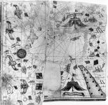
[Τεμάχια ενός πορτολάνου ή ενός άτλαντα των μεσογειακών και ατλαντικών ακτών της Ευρώπης και της βόρειας Αφρικής], Georgio Sideri dictus Callapodha cretensis fecit nel anno Domini 1560
View in English
Georgio Sideri (Callapoda)
[Τεμάχια ενός πορτολάνου ή ενός άτλαντα των μεσογειακών και ατλαντικών ακτών της Ευρώπης και της βόρειας Αφρικής], Georgio Sideri dictus Callapodha cretensis fecit nel anno Domini 1560
Μεσόγειος και ευρωπαϊκή ακτή Ατλαντικού
1560, 0
Τεχνική: Χειρόγραφος
Κατηγορία: Ναυτικός Χάρτης
Διαστάσεις: 542 x 940 mm
Βενετία, Correr Museum, Port. 7.
Venice, Correr Museum, Port. 7.
G. Uzielli & P. Amat , Studi Biografici e Bibliografici sulla storia della Geografia in Italia…, volume II, Mappamondi, carte nautiche, Portolani ed altri monumenti cartografici specialmente italiani dei secoli XIII- XVII, Rome 1882, 246.A. E. Nordenskiöld, Periplus: An Essay on the Early History of Charts and Sailing- Directions, Stockholm 1897, 4.. L. Casanova, Inventario dei Portolani e delle Carte Nautiche del Museo Correr, Bolletino dei Musei Civici Veneziani 3/4 (1957), no.7.S. Makrimichalos, Έλληνες χαρτογράφοι του 16ου αιώνος, O Eranistis 9/10(1966),B.A.Ratti-Paola Ratti- Vidoli, Giorgio Sideri Callapoda, cartografo cretese del cinquecento, Θησαυρίσματα 21(1991), 5.Anna Avramea, Η Χαρτογράφηση του παράλιου χώρου, in S. A. Papadopoulos (ed.), Ελληνική Εμπορική Ναυτιλία (1453- 1850), Athens 1972, 181..Susanna Biadene, Carte da Navigar, Portolani e carte nautiche del Museo Correr 1318- 1732, Venice 1990, 14.C. Astengo, Elenco Preliminare di Carte ed Atlanti Nautici Manoscriti Eseguiti nell\' area Mediterranea nel periodo 1500- 1700…, University of Genoa 1996, ItVe 32.
George Tolias, The Greek Portolan Charts 16th -17th century, Athens, Olkos for the NHRF, 1999, GS.6.
Τρία σπαράγματα ναυτικού χάρτη ή άτλαντα της Μεσογείου. Το έργο αυτό πρέπει να ήταν συναφές εικαστικά με το προηγούμενο (GS.5) καθώς τα υπολείμματά του παραπέμπουν εικαστικά και χαρτογραφικά σε αυτό. Τα σπαράγματα περιλαμβάνουν το μέρος των ατλαντικών ακτών της Ευρώπης, το βόρειο μέρος της Μαύρης Θάλασσας και το ανατολικό άκρο της Μεσογείου. Τα τμήματα που λείπουν ίσως αντιστοιχούσαν σε μεγάλες διακοσμήσεις και αφαιρέθηκαν για να τα χρησιμοποιηθούν για άλλους σκοπούς.
Ο χάρτης φέρει το οικόσημο της οικογένειας Giustiniani και παρουσιάζει τις καλλιτεχνικές και χαρτογραφικές ιδιότητες του προηγούμενου έργου (για παράδειγμα, νοτίως του Καΐρου και στην περιοχή ανάμεσα στον ποταμό Νείλο και την Ερυθρά θάλασσα, απεικονίζεται ένα μνημειώδες αντίσκηνο με την επιγραφή σε διακοσμητική ταινία: Rex de Babilonia. Περιλαμβάνει και αυτό μιλιμετρική κλίμακα στο διακοσμητικό πλαίσιο του χάρτη, ανεμόρρομβους και ανεμολόγιο τριανταδύο κατευθύνσεων. Απεικονίσεις πόλεων, εμβλήματα ηγεμόνων και σημαίες.
Η Βάση δεδομένων «Τεκμήρια Ελληνικής Χαρτογραφίας», περιλαμβάνει το έργο ελλήνων σχεδιαστών και εκδοτών χαρτών από τον 15ο αιώνα έως το 1820. Η Βάση περιλαμβάνει χειρόγραφους και έντυπους χάρτες και άτλαντες, καθώς και νησολόγια. Τα έργα αυτά είναι άλλοτε αυτοτελή κι άλλοτε ένθετα σε γεωγραφικές, ιστορικές ή θρησκευτικές εκδόσεις. Ιδιαίτερη έμφαση δίδεται στην έντυπη διάδοση των έργων των ελλήνων χαρτογράφων. Είναι προϊόν του Ερευνητικού Προγράμματος «Γεωγραφική Παιδεία και Ιστορία της Χαρτογραφίας», με επιστημονικό Υπεύθυνο τον Γιώργο Τόλια, Διευθυντή Ερευνών του ΙΝΕ/ΕΙΕ.
Ινστιτούτο Νεοελληνικών Ερευνών/ ΕΙΕ
Γιώργος Τόλιας
Ναυτικός Χάρτης
[Fragments of a portolan chart or atlas of the Mediterranean and the Atlantic coasts of Europe and North Africa], Georgio Sideri dictus Callapodha cretensis fecit nel anno Domini 1560
Προβολή στα Ελληνικά
Georgio Sideri (Callapoda)
[Fragments of a portolan chart or atlas of the Mediterranean and the Atlantic coasts of Europe and North Africa], Georgio Sideri dictus Callapodha cretensis fecit nel anno Domini 1560
Mediterranean Sea and Atlantic coast of Europe
1560, 0
Technique: Manuscript
Category: Portolan Chart
Dimensions: 542 x 940 mm
Βενετία, Correr Museum, Port. 7.
Venice, Correr Museum, Port. 7.
G. Uzielli & P. Amat , Studi Biografici e Bibliografici sulla storia della Geografia in Italia…, volume II, Mappamondi, carte nautiche, Portolani ed altri monumenti cartografici specialmente italiani dei secoli XIII- XVII, Rome 1882, 246.A. E. Nordenskiöld, Periplus: An Essay on the Early History of Charts and Sailing- Directions, Stockholm 1897, 4.. L. Casanova, Inventario dei Portolani e delle Carte Nautiche del Museo Correr, Bolletino dei Musei Civici Veneziani 3/4 (1957), no.7.S. Makrimichalos, Έλληνες χαρτογράφοι του 16ου αιώνος, O Eranistis 9/10(1966),B.A.Ratti-Paola Ratti- Vidoli, Giorgio Sideri Callapoda, cartografo cretese del cinquecento, Θησαυρίσματα 21(1991), 5.Anna Avramea, Η Χαρτογράφηση του παράλιου χώρου, in S. A. Papadopoulos (ed.), Ελληνική Εμπορική Ναυτιλία (1453- 1850), Athens 1972, 181..Susanna Biadene, Carte da Navigar, Portolani e carte nautiche del Museo Correr 1318- 1732, Venice 1990, 14.C. Astengo, Elenco Preliminare di Carte ed Atlanti Nautici Manoscriti Eseguiti nell\' area Mediterranea nel periodo 1500- 1700…, University of Genoa 1996, ItVe 32.
George Tolias, The Greek Portolan Charts 16th -17th century, Athens, Olkos for the NHRF, 1999, GS.6.
Three fragments of a portolan chart or atlas of the Mediterranean. This work must have been rather similar to GS.5, of which its fragments are ornamentally and cartographically reminiscent. The fragments depict the Atlantic coastline of Europe, the northern part of the Black Sea, and the eastern extremity of the Mediterranean. Perhaps the parts which are missing were heavily ornamented and were removed to be used for other purposes.
The chart bears the coat-of-arms of the Giustiniani family and has all the artistic and cartographic properties of GS.5 (for example, a monumental tent is depicted to the south of Cairo, between the River Nile and the Red Sea, with the inscription Rex de Babilonia). It, too, has a scale bar of miglia in the ornamental border, rhumb lines and a 32-direction wind rose. Cities are depicted, and there are emblems of rulers and banners.
The database “Greek Cartography: the Documents” includes the cartographic work of Greek mapmakers and Greek publishers of maps and cartographic material from the 15th century to 1820. The database contains manuscript and printed maps, atlases and isolarii. The works are either independent either included in geographical, historical or religious editions. Special attention is given to the printing history of the Greek mapmakers’ production. It is a product of the Research Project “Geographical Culture and History of Cartography” supervised by Dr. George Tolias, Research Director INR/NHRF.
Institute Of Neohellenic Research/NHRF
George Tolias
Portolan Chart
